
During one of the sessions on the first day of the World Protech Summit, the General Authority for Real Estate revealed the steps it relies on to improve the classification of real estate data, according to the following steps:
- Reclassifying sectors according to street width.
- Linking raw data using location variables.
- Integration with satellite imagery.
- Using a geographic artificial intelligence model for land classification.
- Linking the results to census data.
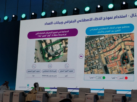
The speaker at the session also revealed an example of using a geographic artificial intelligence model and census data that can distinguish between a building and land, and help correct erroneous classifications, which were previously identified as land to become a building.

The Saudi capital, Riyadh, is hosting the "Global Protech Summit" today, Sunday, organized by the General Authority for Real Estate under the patronage of His Excellency the Minister of Municipalities and Housing, Mr. Majid bin Abdullah Al-Hogail, and in strategic partnership with the National Housing Company (NHC). The summit is witnessing a wide attendance of prominent figures, international experts, and specialists in the fields of real estate and real estate technologies , in addition to more than 100 speakers representing 80 countries, who will exchange their experiences and expertise with thought leaders and CEOs of major real estate and real estate technology companies, as well as investors from around the world.
The summit's discussions will focus on the digital transformation journey in the real estate sector, the role of emerging technologies in shaping the future of proprietary technology, and the latest innovations in modern construction techniques, virtual reality, and artificial intelligence, which contribute to automating real estate processes and services. The summit will also highlight the applications of proprietary solutions in urban development and their role in making smarter decisions to enhance investments and financial sustainability.